|
|
|
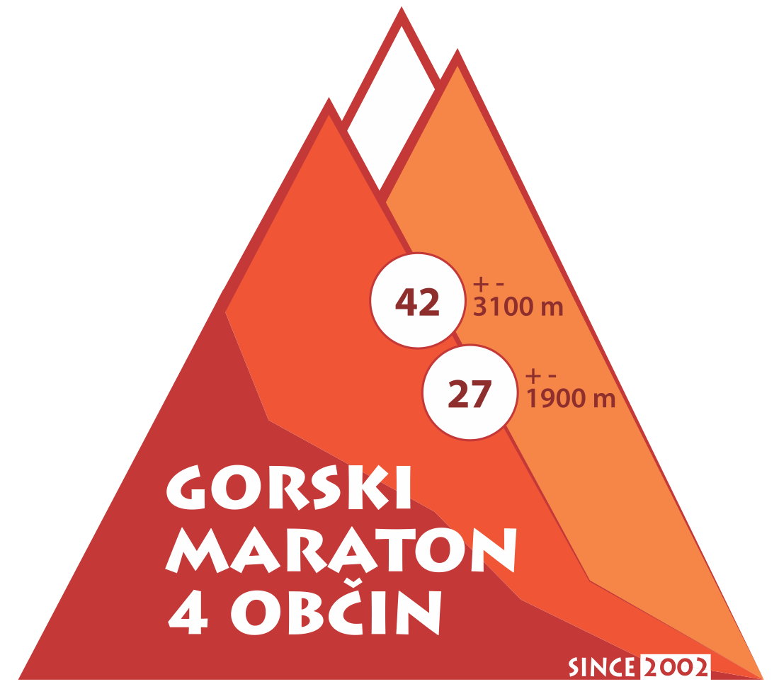
Podbrdo Trail Running Festival |
|
 |
|
 |
|
")


|
|
|
Podbrdo - Slovenija, 16.6. - 18.6.2023 |
| Date | 16. June 2012 |
| Start | Petrovo Brdo (altitude 803 m), 8 a.m. |
| Finish |
Podbrdo (altitude 520 m), anticipated time of the winner: 3 hours and 30 minutes |
| Lenght | 38,5 km, 2500m climbs and 2800m descents |
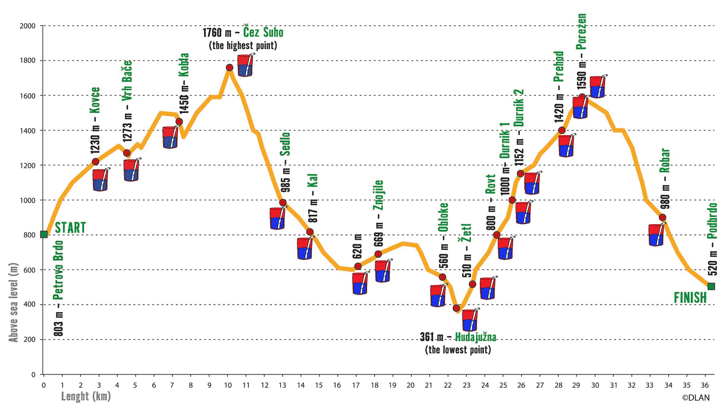
| Description | The race starts in front of a mountain hut on a mountain pass Petrovo Brdo (803 metres above sea level). The first 10 kilometres the track follow the Slovene mountain trail and after the first few kilometres the track reaches Kovce, a mountain plateau, which lies 1230 metres above sea level. In the continuation, the participants follow a nice alpine-runner friendly path, cross Vrh Bače pass (1270 metres above sea level) and run up to Kobla (1490 metres above sea level). After that ascent, the track sweeps gently to Kal, an alpine pasture at 1362 metres above sea level, where another sharp ascent begins and takes the runners to the highest point of the marathon, Čez Suho saddle (1760 metres above sea level), situated just below the summit of Črna prst. The highest point is also an intro to the longest descent (950 metres of height difference) down a marked mountain path over Kalarsko brdo saddle (985 metres above sea level) to Kal, a village at 817 metres above sea level. The participants then follow a nice hunter's path and later a kilometre of an asphalt road before they reach a small village Znojile. A three-kilometre-run over a nice easy ground brings the runners to Obloke, a village at 620 metres above sea level, and later to another village Hudajužna, the lowest point of the marathon (361 metres above sea level). It is of course only logical that from this point onwards the runners are faced with nothing but another long (6.5 kilometres) and steep ascent (1230 metres of height difference), which takes them past lonely farms to the alpine hut just under the top of Porezen (1636 metres above sea level). The runners who have already participated in the marathon named this part of the course “the hour of truth”, so it is no wonder that on this toughest ascent there are five refreshment stops and a doctor. Once reaching Porezen, the last part of the track takes the participants down over Trtnik pastures and past an alpine farm to the finish – Podbrdo. |
| Refreshment station | There are 17 refreshment statios along the course (see course profile). Water, energy drinks and light food will be available. Drinks, light food including fruit and a warm meal are waiting for the competitors at the finish. |
| Datum | 15 junij 2013 |
| Start | Podbrdo (520 m nadmorske višine), ob 8.00 |
| Cilj | Podbrdo (520 m nadmorske višine), predvideni čas zmagovalca 3 ure 45 minut |
| Dolžina | 42,195 km, 2800 m vzponov in 2800 m spustov, skupaj 5600 m |
| Opis proge |
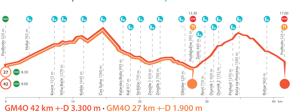
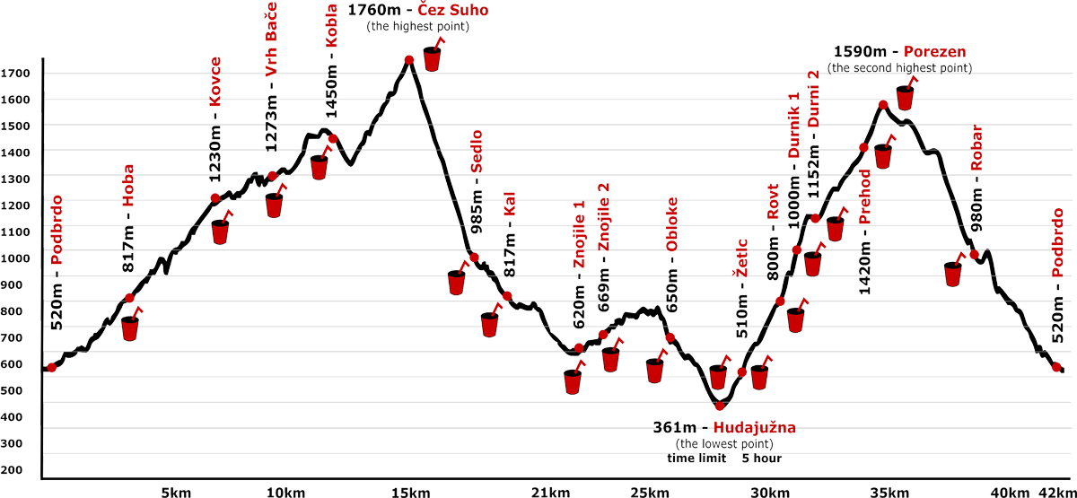
Proga poteka po ozemlju štirih občin: Bohinj, Cerkno, Tolmin in Železniki. Tekmovalce vodi po »mulaterah« in planinskih poteh po pobočjih Črne prst in Porezna. Start je v Podbrdu (521 m n.v.)v samem centru kraja. Novi del proge poteka po stari cesti Podbrdo – Petrovo Brdo do odcepa proti domačiji Hoba, na ovinku pod hišo pa se pot nadaljuje po lepo speljani vojaški mulatjeri pod Kup, kjer je dodana še ena okrepčevalnica. Proga se v prvih treh kilometrih vzpne do Hobe in se v nadaljevanju priključi stezi na že obstoječi progi, ki pripelj do Kovc. (1230 m n.v.) Od tu se proga nadaljuje preko Vrha Bače (1270 m n.v.) do Koble (1498 m n.v.). S Koble se proga spusti na planino Kal (1362 m n.v.), od tu pa se vzpne na sedlo Čez Suho (1760 m n.v.) tik pod vrhom Črne Prsti. Čez Suho je najvišja točka maratona. Sledi najdaljši spust (950 m višinske razlike) po markirani poti preko Sedla Kalarskega Brda (985 m n.v.) v vas Kal (817 m n.v.). Naprej nas pot vodi po asfaltirani cesti v vas Stržišče. Takoj za okrepčevalnico v vasi Stržišče se čez travnike spustimo na stezo, ki nas vodi proti vasi Znojile. (pred vasjo je 1 km asfaltirane ceste). Po dobrih treh kilometrih nezahtevne poti nas proga pripelje v vas Obloke (620 m n.v.), od tu pa se spusti v Hudajužno (361 m n.v.), kjer je najnižja točka maratona. Sledi dolg in zahteven vzpon (dolžina 6,5 km, višinska razlika 1230 m) čez Žetlc, Rovt, Durnik, Robijo in Prehod do koče pod vrhom Porezna. S Porezna (1636 m n.v.) pa se po poti Slovenske planinske transverzale čez Trtniško planino mimo Robarja spustimo na cilj v Podbrdo. |
| Okrepčevalnice | Na progi je razporejenih 18 okrepčevalnic (glej profil proge). Tekmovalcem bodo na voljo voda, energetski napitki in lahka hrana. Na cilju čaka udeležence pijača, lahka prehrana s sadjem in topli obrok. |
| Date: | 15 junij 2019 |
| Start: | Podbrdo (altitude 520 m), 8 a.m. |
| Finish: | Podbrdo (altitude 520 m), anticipated time of the winner: 4 hours and 00 minutes |
| Lenght: | 42,195 km, 2800 m climbs and 2800 m descents, together 5600 m |
| Description: |
The race starts in the centre of the town Podbrdo. The first new part of the tracks follows old road between Podbrdo and Petrovo Brdo till the old house by Hoba, on the turn in front of the house the track follows the old path till Kup, where is the first refreshment. After this first 3 km you’ll find a connection with old track - the Slovene mountain trail and after the first few kilometres reaches Kovce, a mountain plateau 1230 meters above sea level. From there participants follow a nice alpine-runner friendly path, cross the Vrh Bače pass (1270 meters above sea level) and run up to Kobla (1490 meters above sea level). After that ascent, the track sweeps gently to Kal, an alpine pasture 1362 meters above sea level, where another sharp ascent begins and takes the runners to the highest point of the marathon, Čez Suho saddle (1760 meters above sea level), situated just below the summit of Črna prst. The highest point is also an introduction to the longest descent (950 meters height difference) down a marked mountain path over Kalarsko brdo saddle (985 meters above sea level) to Kal, a village 817 metres above sea level. The participants then follow a nice hunter's path and later a kilometre of asphalt road before they reach the small village of Znojile. A three-kilometre-run over pleasant easy ground brings the runners to Obloke, a village 620 meters above sea level, and later to the village of Hudajužna, the lowest point of the marathon (361 meters above sea level). From this point onwards the runners are faced with another long (6.5 kilometres) and steep ascent (1230 meters height difference), which takes them past lonely farms to an alpine hut just under the top of Porezen (1636 meters above sea level). Runners who have already participated in the marathon have come to calling this part of the course “the hour of truth”, so it is no wonder that on this toughest ascent there are five refreshment stops and a doctor. After reaching Porezen the last part of the track takes the participants down over the pastures of Trtnik and past an alpine farm to the finish – Podbrdo. |
| Refreshment stations: | There will be 18 check points. On refreshment stations there are drinks and snacks. |
|
Registrations with payment |
|||